- Iceland
- South Iceland
- Hiking to the Lost Paradise of Rauðibotn

There are fantastic landscapes on Earth, few people know about them and they take us on a journey to another planet. The landscapes around the crater of Rauðibotn, along the Hólmsá River are part of these mysterious scenery, which will enchant you at first sight. If you have the soul of an adventurer, come and get lost north of the F210.

Summary
1A lost paradise
If Rauðibotn is a lost paradise, it's because this place is still difficult to reach, away from tourist sites and route n°1. No guide (to my knowledge) indicates its existence. There are no marked trails, no official parking, no signs to indicate the location. There's no evidence of this fantastic place. So to find this lost paradise, follow our instructions.
Access by 4x4
On the F210, on the east bank of the Hólmsá ford (about 1.5 km west of the junction between the F233 and F210), there is an unmarked runway on the east bank of the Hólmsá ford, but it is still quite marked to the north. It crosses a small arm of the Hólmsá river and climbs slightly, continuing a few hundred metres to the west.
Be careful when crossing the ford on the Hólmsá river, which can be dangerous depending on the weather conditions and snowmelt. It is quite wide, the bottom is very sandy and the water level can be quite high. About 55/60cm of water when we passed there in July 2016 knowing that the Hólmsá seemed low enough upstream. Note that the level can easily reach 80cm (indicative level because the variations can be very strong).

The small track gradually takes off from the altitude until it reaches the summit of a promontory which ends in a dead-end street. Traces of quads go straight north on a very steep slope. Leave your car here, the platform is big enough to park several people. Already from here you can contemplate the panorama of the Hólmsá and the seemingly infinite plain, dotted with green mountains.

The beginning of the hike
Follow the tracks of quad bikes on foot which go up the steep slope. These tracks will serve as a reference for us to reach the crater. On your right, you will see a hiking trail that runs along the hillside. Do not take it because it does not lead to the crater of Rauðibotn and branches off after a few tens of meters to the right.

The quad tracks continue to climb, crisscrossing fragile vegetation made up of large cushions of moss. In some places, the water feeds the soil and allows other types of lighter mosses to grow, creating nice shades of green.
Pay special attention to the very fragile nature here. If you can, avoid leaving footprints to preserve vegetation..
Heading towards the crater
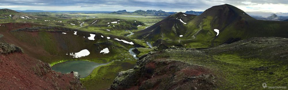
After climbing the first hill, the ascent becomes softer. After about 1 km, the landscapes are beginning to unfold. The first contours of the glowing Rauðibotn crater appear and the Hólmsá appears below.
The path then descends a few tens of meters just before the crater ascent. At this point, you may see a westbound trail leading west down to the Hólmsá (about 1.2 km from the start), while the quad tracks continue northward. We advise you to borrow it on the way back, to make a loop that will allow you to go around the crater from the top and discover the most beautiful views. To identify this trail properly (we didn't notice it on the way out), we advise you to use the small map at the bottom of the article where it is clearly visible, because on the ground, the quad tracks are much wider and sometimes the small trail is almost erased.
The rise of the crater
The quad tracks are heading for the edge of the crater. This part of the ascent is the most strenuous as the slope is very steep. But the few efforts will be well rewarded because little by little, the altitude will reveal all the colors of this sublime landscape that is finally revealed!
Arrive halfway with the point the highest point, approach the edge.


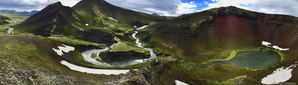
Wow, it's absolutely grandiose, the landscape seems hardly realistic! The crater's heart appears, revealing a small emerald green lake surrounded by red rocks. To the left, the Hólmsá snakes in the middle of a foam decoration carved by the force of water. The scene seems chaotic and exceptionally beautiful.
We'd be spending hours contemplating this fascinating landscape!
The ascent continues upwards towards the crater. The slope is now less steep, even the ascent remains tiring. The quad tracks are less visible because this part is more exposed to the weather. If the weather is windy, you are likely to have a lot of wind.
Finally, the last efforts are rewarded by the breathtaking view from the summit. What an explosion of colors!
An almost fluorescent green crown encircles the small emerald lake in the heart of the crater's glowing red slopes.


From this point, the quad tracks seem to disappear, or go down to the other side. We will continue without traces, with the aim of joining the trail that ran along the Hólmsá that we had seen before.
We recommend that you go down towards the southwest to find a smoother slope. On the side of the crater, a few rocks make it easier to move forward and thus avoid damaging the fragile foam.
Take time to look southwest, just behind the ridged green moss hill. Deep down, alone, lost in a black desert of loneliness, the Maelifell proudly sits in front of the immense Mýrdalsjökull. A little further down, this time to the northwest, a large turquoise blue spot appears. The small task widens as the descent goes down to reveal a large lake: the Hólmsárlon. That's beautiful!


The water that is discovered is a beautiful turquoise blue milky blue, bathed in a decor of green moss.
By the Hólmsá River
We have now reached the Hólmsá river bank. If you reach the shores of the lake, it's because you've been too far north. In this case, walk along the lake to the left (downstream) and the trail should appear just at the end of the lake, at the level of the small waterfall.


Once on the trail, you can either continue up the Hólmsárlón or complete the loop. If you look at the opposite bank, you will see a path drawing. This is the continuation of the route which, if we continue for several kilometres, will take us to Strútur and its hot spring.
You can, if you wish, continue in this direction and walk along the great lake, but you will have to ford through the Hólmsá at the waterfall just before the lake forms. Look at the map at the bottom of the article, the trail is indicated.

But as far as we are concerned, having not gone further for lack of time, we propose to complete the loop to reach the small lake of Rauðibotn.
The trail continues along the Hólmsá River, passing by several very different small waterfalls. There are all kinds of them, it's very pleasant! The ideal place to break the crust because here we are rather sheltered from the wind. The river continues to descend dotted with large basins of superb turquoise blue incite to the cold bathing.

The trail now reaches the level of the small Rauðibotn lake, which was discovered from above. The water from the lake flows through a small channel to reach the Hólmsá, which we will have to cross, or rather jump, to continue our way. The arm is not very broad but enough to require a little momentum (I will say about 1m30). Otherwise you will have to remove your shoes to cross it knowing that there is not much water or flow.

Once past this obstacle, the trail runs along the Hólmsá for a few more metres, then rises above a slope to reach the quad tracks. At this point, a large slab of snow had blocked the road, forcing us to "make" an ice staircase to climb the snow.

On the other side, the landscapes are familiar, and after 300 meters the quad track reappears. It will then be enough to follow the tracks to the end and thus regain the starting platform.
A short, short hike revealing extraordinary landscapes.
A very little-known place where you will have to be alone in the world.
The colors!! It's fantastic, we're getting a lot of attention.
We are Sandrine and Flo, French thirty-somethings. In 2019 we quit everything to live our dream, become nomads and travel around the world. We left with our baby, Lena, who was only 5 months old at the time. After a first trip around the Pacific Ocean by plane and a long 3 months stay in Hawaii, we left to discover Iceland for 3 months on board our 4WD pickup truck and truck camper. Then we continued our adventure in North America.

Today, if we can continue this adventure, it is above all thanks to our blog, Smartrippers! We created it one day in 2016, with the desire to share our good travel tips, without thinking that it would lead us there! We have developed it a lot over the years and have become experts on our 3 favorite destinations: Hawaii, Iceland and the American West. We now guide you to these destinations to help you plan the trip of your dreams!
Follow our adventures!