
The Hāna Highway is a very famous and beautiful 109 km long winding road that crosses the humid north and east coast of the island of Maui. With its 620 turns and 49 bridges, the Hāna Highway is a must-see in Maui!
The long road crosses and serves the varied landscapes of the eastern part of Maui, starting with countless waterfalls that hide in every corner of the very rugged and verdant terrain of the northeast of the island. It then leads to the jagged relief of the coast near Hāna and to discover beautiful black, red or beige sandy beaches. Finally, it also serves the superb Pīpīwai trail and its waterfalls in the south-east of Maui.
The mile 0 marker that indicates the start of the Hāna Highway is located at the very beginning of Highway 360, although on the maps, the Hāna Highway also takes Highway 36 located upstream from Kahului (the interesting road really only starts at the marker 0). The Hāna Highway then follows the coast before joining the Piilani Highway, or Highway 31 at Kalepa Gulch in the south-east of the island.
We propose you to travel the entire famous Hāna route from marker 0 to the Kalepa Gulch, stopping to let you discover the countless points of interest and other little secrets hidden by the Hāna Highway. You will also find our practical advice at the end of the article.
Summary
1From mile marker 0 to Ke'anae
This first part of the Hāna Highway begins with many bends and single-lane bridges providing easy access to a few waterfalls. The road will then take us to Ke'anae and its small peninsula famous for its impressive waves. Along the way, we will also have the opportunity to discover the rainforest with some beautiful specimens of trees.

The Twin falls
These waterfalls are the first to be seen on the Hāna Highway. The waterfalls are easy to access thanks to a large roadside car park, but they are also very busy.
They are actually three small waterfalls. The first two, the Lower Falls, can be reached from a wide path while the last one, the Upper Falls, is located further south and will require fording a river at the end of a more difficult walk.
The first of the Lower falls is quite discreet with its basalt wall and swimming pool where it is possible to swim. The waterfall is not very big or powerful, but the setting is pretty.

The second one is located a little further upstream, just before the wooden gate that conditions the access to the continuation of the walk leading to the Upper falls. Similar to its sister, it also has a small basalt wall and a basin for bathing.

Shy on the day of our arrival, the two waterfalls can be completely different and much more impressive after a heavy rain.
.")
Beyond the gate, the path continues to the Upper falls, also called Caveman falls. The gate will only be opened if the access conditions are not dangerous.
Unfortunately the gate was closed when we came and so we couldn't go to the third waterfall. We cannot tell you more about the path after the gate, but it seems that it is the most beautiful of the three because it rises above a small cavity. You can find some pictures on the Wailele Farm website.
How to get to Twin Falls
The waterfalls are located below the Wailele Farm's private road, which is open to the public every day free of charge. There is a dirt parking lot right in front of the farm's produce booth which is located at mile marker 2 of the Hāna Highway.
Access to the Lower Falls is possible from 7am to 6pm and to the Upper Falls from 8am to 5pm. The fruit stall right at the entrance is open from 8:00am to 4:00pm.
Wakamoi nature trail
Loop from 700m to 1.7km - 20 minutes - Easy
Here is a short trail that will allow you to discover the rainforest and its lush vegetation, dotted here with large eucalyptus and other trees with giant roots.
This small trail makes a loop of 700m with an option to go up to a picnic area (add 1 km round trip). It is covered quickly and will be very interesting if you have not yet had the opportunity to walk in the heart of the rainforest. The route is indicated in green on the map at the bottom of the article.

A few small signs indicate vegetation here and there. The views are not fantastic but the walk in the trees is nice!
Our tip: make the loop in a clockwise direction starting with the path going down.
How to get to the Wakamoi nature trail
The trail starts at a small parking lot that allows a few cars to park on the side of the road. The parking lot is not signposted but it is still clearly visible on the right side of the road.
Wakamoi waterfall
A little after the Wakamoi nature trail is the Wakamoi Waterfall, a cute little waterfall that flows into its pool perfect for swimming. It is quite easy to reach it thanks to a few steps that allow you to go down to the edge of this pretty waterfall.

How to get to Wakamoi waterfall
The waterfall is just before a gulch which the road crosses by a small one-lane bridge. It is possible to park 2 vehicles on the lower right-hand side just before crossing the bridge. Another parking space is also available on the right side just after the bridge. Then you will have to take the small passage that goes on the right before the bridge and allows you to go down quickly to the waterfall..
Garden of eden
We didn't take the time to stop at this small arboretum which offers you to discover many varieties of plants and flowers, but also to access several viewpoints which allow you to see two waterfalls only visible from the gardens.
It will cost you 15$ per adult for the visit. The arboretum is open every day from 8am to 4pm.
Ke'anae Peninsula
Be sure to make a quick detour to the small Ke'anae Peninsula. In case of heavy surf, the waves here are immense and form large rolls that crash on the black rocks of the steep coast. The spectacle is captivating!

You will find several parking spaces all around the peninsula that will allow you to easily stop and watch the waves.
We stayed here for several minutes watching the waves breaking. When the ocean is really rough, it must be quite exceptional, especially since the place is not very crowded with tourists.
 Large waves crashing north of the peninsula.
Restrooms are located in the park at the end of the peninsula.
How to get to the Ke'anae Peninsula
To reach the peninsula, you will have to leave the Hāna Highway and take the Keanae road, a small narrow road that descends to sea level. Then stop whenever you wish. You will then have to turn back, as the road does not go all the way around the peninsula.
2From Ke'anae to Nahiku
The road continues to meander through the rainforest. The waterfalls are becoming more and more numerous and when it rains, many streams of water form at the bottom of the many gulches that are crossed by the road.

Chings pond
The small natural swimming pool of Chings pond is situated below the road. A small steep dirt path leads down there, but a sign says "residents only". Indeed, the locals who are used to come here are not very welcoming with tourists...

Kaumahina State Wayside
Although the place is well signposted with a large car park, you won't find anything special here apart from a view of the Ke'anae peninsula and sanitary facilities and a few picnic tables.

Upper Waikani Falls (Three Bears waterfall)
This pretty waterfall directly visible from the roadside is formed by 3 streams of water. It's nicknamed the Three Bears waterfall, in reference to mummy and daddy bear (the two big waterfalls) and their baby (the third and last smaller waterfall)... but don't ask me why they are called Bears!
The pool at the foot of the 3 falls is also nice to go swimming there because it is set back from the road.

How to get to Upper Waikani Falls
Although the waterfall is easily visible from the side of the road, access is complicated by the fact that there is only one place to park and admire it. Hopefully, the small spot will be free to park for a few moments on the side of the road just before crossing the one-lane bridge over the river.
If you then want to get closer to the pond, you will have to cross the small parapet that borders the road and go down through the vegetation.
Kopiliula falls
Round trip of 1,5km - 30 minutes - Easy
This is one of the little hidden gems of the Hāna Highway that can be discovered after a short and easy walk of about 700 meters. The Kopilula falls flow in a beautiful green setting and even allow you to swim in a natural swimming pool located upstream.

To reach it follow the track that goes up until you arrive at a kind of intersection (it is a private stony path closed by a barrier, but access is allowed by foot). After 350 metres, leave the track on your left and go straight on. Soon you will see a natural amphitheatre where the beautiful Kopiliula waterfall and its little sister, that you can guess above it, appear. The setting is sumptuous!
Then follow the path that goes around the amphitheatre with beautiful views of the waterfall and its emerald basin. The path could be a bit muddy on this portion.

We then arrive at a bridge from where we discover another small waterfall that flows into a beautiful natural pool. Impossible to resist the temptation to swim here!

To get to the second waterfall, take the small path that leaves on the left before reaching the bridge. After a few meters, it brings us to the natural pool where a small beach allows an easy entry into the water.
Flo was tempted to go swimming! It was invigorating! But after a few minutes of adaptation it was really nice.
In order to have the most beautiful colors and enjoy the bathing, we advise you to come around noon or early afternoon because afterwards, the sun will be hidden by the peaks behind the waterfall.
The trail then continues for a few hundred meters after crossing the bridge but it only leads to a small river with no real interest.
How to access the Kopiliula falls
Leave your vehicle on one of the few low recesses located just before, in front of and after the private road and then drive along the roadside to the beginning of the trail. The route of the hike is indicated in purple on the map at the bottom of the article.
Pua'a Ka'a State Wayside
The Pua'a Ka'a State Wayside consists of a part on the left side of the road with a parking lot, sanitary facilities and several picnic tables in the shade, and a part on the right side of the road leading to a small waterfall where you can easily swim.
The place being very easy to access, it is therefore quite busy.

Hanawi Falls
The Hanawi Falls are located below the Hāna Highway. On a nice day, swimming can be very pleasant in the small lagoon below the waterfall. The color of the water is superb and it is possible to swim a little, the water being deep here.

However, as with all waterfalls, they could become very dangerous after a heavy rainfall, turning the peaceful lagoon into a bubbling pond!
How to get to Hanawi Falls
As with most of the waterfalls along the Hāna Highway, hopefully there will be room to park on the lower side (about 2/3 spots) on the right side of the road before the bridge. Then, access will be via a rather steep dirt road that goes down to the waterfall. A rope will be useful to avoid slipping.


Makapipi Falls
The particularity of Makapipi Falls is that the waterfall rises under the bridge that crosses it. Unlike other waterfalls, it is only visible from above. But the disappointment comes from the fact that the riverbed has been laid out for probably practical reasons, which takes away all the natural charm of this waterfall although it is pleasant to look at from above.
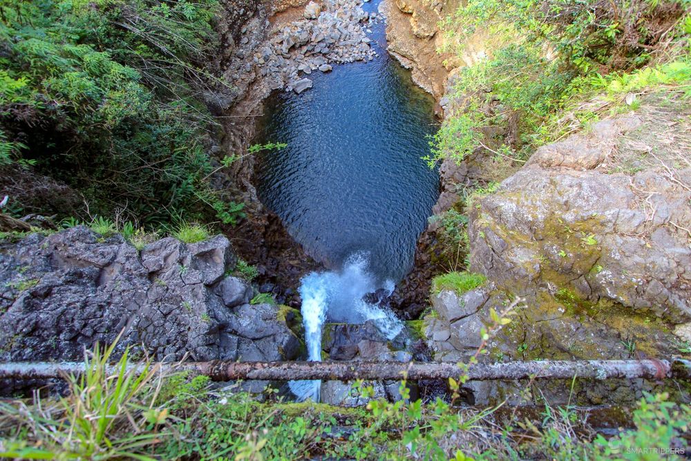 The view of the Makapipi falls from the bridge.
How to get to Makapipi Falls
To see the waterfall you will have to walk to the middle of the bridge and look underneath on the ocean side. A large piece of land on the right side of the road after the bridge allows several vehicles to park there easily.
Nahiku Viewpoint And Wayside
In the same spirit as the Ke'anae Peninsula you can also go to the ocean at Nahiku. There again the waves will crash over the steep coastline and black rocks.
Unfortunately we didn't have the opportunity to go down there, but a round trip should be quite quick to make from the Hāna Highway by taking the small Nahiku road.
Hana Lava Tube
For $12.50 per person, you will be able to visit this lava tunnel which is said to be the largest in Maui (according to the staff we met on site). Count on about 35 minutes of visit to wander in the cave to discover it. The flashlight is provided with the entrance ticket.
We didn't test it because we were with our baby, but be aware that there are other free lava tunnels, such as the Kaumana Caves on Big Island, which you can visit on your own if you are equipped with a headlamp.
Wai'anapanapa State Park
Located north of Hāna, this State Park is a little gem! Here the shredded black lava meets the deep blue ocean. The carpet of vegetation that covers the black rocks offers a striking contrast in this beautiful landscape. One could spend hours contemplating the sea and the waves crashing on the rocks, projecting geysers several tens of meters high!

Too bad the number of visitors is so high, costing him his fifth star.
To make the most of it, we advise you to park in one of the 4 car parks of the site and then to walk along the very pretty coastal trail which passes through all the points of interest on the way there and back. You will discover Maui's famous Black Sand Beach, which is very popular because of the number of swimmers we met here!

To the right of Black Sand Beach there is a small cave that can be explored when the tide allows it, by sneaking in through the small hole whose entrance is on the beach.

Continuing after Black Sand Beach, the trail gets a little higher and arrives near large rocks where the waves come crashing throwing water in the sky, sprinkling the tourists who came to have their picture taken at this place!

Just after, we will discover a second beach covered with small black pebbles which is this time much less crowded and more conducive to relaxation.

The trail continues past the beach and crosses several coulees before rejoining the ocean front again. This last part of the trail is very little used because the vast majority of walkers do not venture beyond the second black sand beach.
Be careful when crossing Black Sand Beach as the waves can easily cover the whole beach and get your feet wet.
How to get to Wai'anapanapa State Park
Wai'anapanapa State Park is easily accessible from Waianapanapa road. The park is free and has 4 parking lots. The most practical is the first car park that you see when you arrive, because it allows you to do the trail from the beginning, but unfortunately it is also the most busy.
The last car park could be interesting for a direct access to Black Sand Beach, or to come to settle down at one of the few picnic tables. Sanitary facilities as well as camping and cabins are also available on site.
3Beaches to discover around Hāna
The small town of Hāna is located in the far east of Maui. Famous thanks to the road of the same name, the small town has however only a thousand people. It must be said that the village is really not easy to access, either from the north or the south! In fact, if you're looking for accommodation or food at Hāna, expect prices to explode here.
Apart from that, the bay and peninsula of Hāna hides several beaches, including the sublime Kaihalulu Beach with its red sand!
Kapueokahi Beach
This large wild black sand beach of about 400m is located north of Hāna. People come here more to walk along the ocean than to swim. The stroll in the calm at the sound of the waves is very pleasant and the landscape is charming here, the bay of Hāna in the background. And there is nobody here!

There are no facilities near the beach.
Hana beach park
The Hana Beach Park offers sanitary facilities with showers as well as numerous picnic tables at the water's edge. This is the only really interesting thing here, because the beach is not very attractive for swimming.

On the other hand, you will be able to go to the end of the road which ends in a cul-de-sac up to the level of the boat ramp to discover a pretty panorma on the bay of Hāna.
Kaihalulu Beach (Red Sand beach)
This is one of the most beautiful and amazing beaches in Maui! Kaihalulu Beach, more commonly known as Red Sand Beach, has the distinction of being, you will have understood it, a red sand beach! And that's not all, because in addition to its flamboyant sand, it is also a very pretty beach located in a natural setting reserved for those who want to venture to the end of the wild coast south of Hāna.

Because the flip side of the coin is that access to Red Sand Beach is not easy. Although it is short, the 350m trail is quite steep and slippery. The trail is covered with many pine needles and a rather brittle ground, which makes it dangerous even in dry weather.

We experienced this with a nice slide on our buttocks on a sunny day!
But if you proceed with caution, you will quickly discover a superb panorama of the entire wild coast before finally reaching the first reddish rocks that mark the beginning of the beach. The latter is nestled in the heart of a small rocky amphitheatre where the rock crumbles, dropping the famous red sediments that form the beach.

Once in the ocean, the red sand gives a beautiful emerald colour to the water, it's just beautiful!
Finally, a natural rocky barrier protects the beach from waves and currents and makes it suitable for swimming, which we like!

Lastly, the difficulty of access and the remoteness of the beach located just east of Maui means that Red Sand Beach remains relatively little frequented despite its reputation.

How to get to Red Sand beach (Kaihalulu Beach)
Access to Red Sand beach is from the end of Uakea Road in Hana. Parking is fairly easy to find in the surrounding area. Take Uakea Road towards the ocean and turn left just before the gate that closes the road. You will then pass through a large green area and you will need to find a path through the bushes on the right that will lead you to the access trail.
Then you just have to follow the path for 300 metres, which will take you to the beach in a few minutes. Be careful on the very slippery descents, especially if you are wearing flat-soled shoes.
4Beaches and coastline south of Hāna
Koki beach
The small Koki beach has the particularity of being close to the glowing red cliffs south of Hāna. Although its sand is not really red, the contrast of the cliffs at the end of the beach with the sand is rather nice. It is also possible to swim here if the ocean is not too rough.

How to get to Koki beach
Access is easy from the Haneoo Road, a small side road that passes close to the beach and allows parking in the shade of the trees. It is possible to swim here but beware of the waves.
There are no sanitary facilities on site but a few picnic tables in the shade allow you to have a bite to eat.
Hamoa beach
Hamoa beach is a pretty clear sandy beach in a charming setting that is still a little wild. It is located in a small residential area along Haneoo Road, just off Koki beach. Its remoteness makes it very little frequented and therefore pleasant to swim there away from the crowd.


How to get to Hamoa beach
Parking is easy on the shoulder of the road. A staircase leads to the beach where there are showers and sanitary facilities. A deckchair rental service is offered by the small adjoining hotel.
Waioka Pond (Venus Pool)
Waioka Pond is a very pretty little pond formed at the mouth of a river that flows into the ocean when it is not dry. The place is perfect if you want to try your hand at jumping into the ocean, as long as it is a minimum of calm. One of the favorite activities of the local youth.

How to access Waioka Pond
There are no particular difficulties regarding the access path, it will just be necessary to locate the beginning of the path which starts at the parapet on the side of the roadside "parking lot". It then goes a little deeper into the vegetation before being blocked by a railing that you will have to cross over it. A sign indicates that the access can be dangerous and that it will be at your own risk. A descent into the undergrowth will then lead you to a natural headland from where you will discover the area. Allow less than 5 minutes to reach the "play area"!


5The tropical south and the end of the road from Hāna
After a drive along the ocean, you enter the lush forest again and the road takes its many bends before reaching the Kīpahulu area of the Haleakalā National Park. For the last few kilometres, the landscape changes again to open up to the ocean before reaching the Kalepa Gulch which marks the end of the 109 km long road to Hāna.

Wailua falls
Quickly we arrive in sight of the Wailua falls, a real tourist trap which at times causes traffic jams on the small road of Hanā, because the number of parking spaces is limited and the car park is far too small to accommodate the numerous tourist mini-buses which all stop here.
Nevertheless the waterfall is very beautiful. But to discover it, you will have to find a parking space and take a short, very slippery path, slightly muddy but with many wet rocks.


Once at the foot of the waterfall, you can try a little swim in the cool waters if you feel like it. Unfortunately, the large number of visitors takes away a lot of charm from this pretty waterfall...
The Ohe'o Gulch via the Kuloa Point Trail
Loop of 900m - 20 minutes - Easy
We now come to the Kīpahulu sector of the Haleakalā National Park, an annex area of the Haleakalā park that extends to the sea. This area is rich in waterfalls and can be discovered on foot thanks to short hikes.
The first of these is the Kuloa Point Trail, which takes you to discover the Ohe'o Gulch, along which 7 successive waterfalls rise, some of which have small natural pools where it is sometimes possible to swim.
The walk is easy with a slight difference in altitude and takes about 20 minutes without counting the various stops. The track is displayed in orange on the map at the bottom of the article.


But for several years now, there have been few times when it is really possible to bathe here, because the presence of bacteria or the danger due to unpredictable floods are often the cause of fairly long closures. It is therefore better not to have the idea of diving in the water here in mind.
Note that you will have to pay an entrance fee to the National Park to access the park. If you buy the single access pass at $30/car, please note that it is valid for 3 days. In this case, it will be interesting to combine your ascent to the top of Haleakalā during this period to avoid having to pay for a new pass, unless you opt for the Hawai 'i Tri-Park allowing access for 1 year to the 3 national parks of Hawaii for $50/car.
Pīpīwai Trail
Still in the Kīpahulu area of the Haleakalā National Park, the Pīpīwai Trail is simply the most interesting hike in Maui. It is a must not to be missed when you come here, as long as you have at least 2h00 to 2h30 to devote to it, the time to make the round trip of 5.8 km to the end of the trail which allows you to discover the superb Waimoku falls and to cross magnificent bamboo forests along the way.

To learn more about the Pīpīwai Trail and its itinerary, we recommend that you read our dedicated article: Pīpīwai Trail: Maui's must-do hike. The trail is indicated in red on the map at the bottom of the article.
The last kilometres of the Hāna Highway
If you wish to continue the Hāna Highway all the way to the end at Kalepa Gulch and why not try a grand tour of East Maui via the Piilani Highway, you will be taken to the steepest section of the Hāna Highway which runs along the ocean side of the cliffs for a few hundred meters, and sometimes in only one lane!

But fortunately, this last section of the Hāna Highway is only very little used because many tourists don't dare to venture on the Piilani Highway. Yet this road is superb despite the few unpaved portions that do not justify the fear of this road considered "dangerous".
If you decide to go through, just be careful in narrow areas and don't hesitate to honk your horn before entering single-lane sections if you have no visibility.
Here we are now at the end of the 109 km of the Hāna Highway. A small sign will warn you of the junction between the Hāna Highway and the Piiliani Highway which will take over at the Kalepa Gulch.
.")
6Our advices before taking the Hāna Highway
Be patient and take it easy!
First of all, be aware that you'll have to be patient all along your road-trip on the Hāna Highway because many frightened tourists drive very, very slowly in the curves, or even stop as soon as it's a bit tight! So the journey seems long, very long!
So relax before you get behind the wheel and don't impose a timing on this road or you'll go crazy, and be ready to drive at 20mph (30km/h) for a long time.
How long will it take to travel the Hāna Highway
In terms of timing, it will take about 3 hours to cover the entire 109 km of the Hāna Highway without stopping. A big day is thus necessary at least to discover the many points of interest and make the few hikes of the Hāna Highway.
It will also be necessary to think about the return trip, that is to say to redo the 109 km in the other direction, or to continue the Piilani Highway (Highway 31) which is much more driveable.
Of course, you won't be able to do all the points of interest of this article in a single day. You would easily need at least 2 full days to see everything! So you'll have to make a selection among the waterfalls, beaches and hikes to see, unless you stay one night at Hāna, but you might have to depend on the weather.
Note that there is almost no GSM network along the entire route. So prepare your maps and itinerary in advance.
Which way to go on the Hāna Highway
The option we recommend is to start on the Piilani Highway and continue on the Hāna Highway. This means taking this article from the end! This will allow you to do the Pīpīwai Trail early and avoid the morning rush in the northern area. However, watch your timing to have time to make a few stops on the northern part because night falls quickly in Hawaii!
When to drive the Hāna Highway
The tropical parts of the north and south of the Hāna Highway will be more beautiful after a rainy episode. It should be noted that the waterfalls will be more or less beautiful and impressive depending on the weather of the days or even hours before. The rains contribute to the beauty of the waterfalls and the dry episodes sometimes make some of them disappear until the new rains. Conversely, if it is too wet, some waterfalls will be transformed into large brown torrents, which will not be very beautiful either.
Finally, more generally, be very vigilant because the risk of flooding is important here in case of rain, as waterfalls and torrents can suddenly swell and become dangerous. Therefore, only swim in them in dry weather.
You are now ready to set off to discover the Hāna Highway! Hopefully you will have the best conditions to discover it. And don't hesitate to leave us a comment to let us know what you think about your experience :-)
We are Sandrine and Flo, French thirty-somethings. In 2019 we quit everything to live our dream, become nomads and travel around the world. We left with our baby, Lena, who was only 5 months old at the time. After a first trip around the Pacific Ocean by plane and a long 3 months stay in Hawaii, we left to discover Iceland for 3 months on board our 4WD pickup truck and truck camper. Then we continued our adventure in North America.

Today, if we can continue this adventure, it is above all thanks to our blog, Smartrippers! We created it one day in 2016, with the desire to share our good travel tips, without thinking that it would lead us there! We have developed it a lot over the years and have become experts on our 3 favorite destinations: Hawaii, Iceland and the American West. We now guide you to these destinations to help you plan the trip of your dreams!
Follow our adventures!