- Iceland
- South Iceland
- Discover the F210, one of the most beautiful tracks in Iceland

Breathtaking landscapes, an atmosphere at the end of the world and tens of fords! Between the Eyjafjallajökull and the Hekla, bordering the rhyolite hills of the Fjallabak reserve and the immense Mýrdalsjökull, the F210 track takes us through incredible landscapes for 115 km!
Twice, we went through it during the summer of 2016 and each time it fascinated us. The F210 is one the top of our ranking of the most beautiful tracks in Iceland.

Summary
1In which direction driving on the F210 ?
We recommend that you drive the F210 from west to east and start your journey on Route 264 until you reach the F210, signposted "S. Fjallabak". This access will allow you to discover the first relief of the green hills of the Falljabak reserve before diving into the Maelifellssandur desert.
At the exit of the Mælifellssandur you will have the choice to continue on the F233 to join the F208 in the direction of Landmannalaugar in the north, or to return to road 1 in the south by continuing on the F210 until the end, or to follow the Mýrdalsjökull by taking the F233 (option that we advise you if you do not wish to cross the Hólmsá).

Expect to be alone, this track is not very busy even during the summer because a good 4x4 is necessary, and that's good!
Our tips:
We will therefore detail the itinerary in the direction we recommend, from left to right.
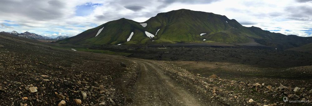
2The first kilometers on F210: entering a new world
Our journey begins at the junction of Highway 264. The first few meters on the F210 track are rather classic. The track is still a gravel road. We are here in the heart of a vast grassy plain. In the distance, if the weather is clear, you can see the Eyafjallajokull ice cap.
Pretty soon, the track becomes very stony and much less rolling, but fortunately this unpleasant portion is not long. After a few minutes, the track becomes soft and smooth as it gets rolling, taking a little altitude. It continues eastward, crossing vast stretches of razor-sharp grass with beautiful colour shades.

The small hills on the right side of the track are dyed red. Soon, the grassy plain gives way to an inhospitable and barren expanse. We switch to a completely different desert universe, made up of volcanic ashes, it's fascinating! For several kilometers the trail crosses desolate landscapes, following a small river winding on the right below.

Then, this strange decor gives way to a new wet plain. The first reliefs begin to appear rising around the track, forming small hills covered with moss. The soil now has thousands of small white and pink flowers on the ground, forming a small colourful carpet. In the background, the reliefs are covered with snow, revealing beautiful contrasts.


From now on, the track advances in a universe that seems more hospitable. Now the water seems to be plentiful and small waterfalls are rising to the right of the runway. Soon the first ford arrives and will follow about twenty others. At first, they were rather stunted, but they soon became more and more impressive.

At the end of the route, rhyolite hills appear, marking the beginning of the Fjallabak Reserve, which will be followed by the F210 trail for several tens of kilometres.
3The surroundings of the Fjallabak reserve: passage into an unreal world
From this point onwards, the landscape changes again and now forms beautiful hills with orange, green and sometimes red hues, always snow-speckled. The track now crosses a small lava field whose clusters resemble petrified trolls. The trail runs in the middle of this amazing scenery. There's no one, we're alone in the world!

Soon the track will be covered with water. It seems oddly enough, it seems to pass through the river bed for several hundred meters without being seen at the exit! Then suspicious, we slowly roll in the water which does not exceed a few centimetres. After about 400 meters the track finally branches off to the right. Be vigilant and take the right exit. If you are concerned about this portion, please feel free to walk to the area.


Crossing Markarfljót
After passing through the riverbed, the trail climbs up a small slope to a wide plain where the Markarfljót winds its way to the bottom. The river is rather wide and seems to flow peacefully in the middle of a small green valley.

The track descends in laces to the shore. In the distance, the Mýrdalsjökull now dominates the landscape.

Closer to home, the river seems much less calm and rather deep. Although the water is clear, the current seems to be quite strong. Fortunately, it goes in our direction which facilitates our crossing. I'm not sure we could have crossed the river if we came the other way.
The crossing takes place in several stages. We proceed carefully and cross the multiple arms forming the Markarfljót. Some of them are quite deep (just over 60 cm with a few holes and large stones in the bed).
Panorama over the glaciers and hills of rhyolite
After crossing the river, the trail climbs upwards and looks for one of the most beautiful views of the F210. We take altitude with some fairly steep sections, then after reaching the top of the coast, the trail takes us to the heart of an exceptional landscape. We stop in the clear to contemplate this sublime landscape. We'll be here for long minutes to devour it with our eyes.

The green and steep hills seem to have been carved into this surrealist landscape. In the distance the majestic Mýrdalsjökull indicates that we are approaching the Maelifellssandur. Between two hills, you can see Lake Álftavatn. It's just magic!
Lake Álftavatn's shores
The trail now descends down towards the shores of the lake, which it runs along for a few metres. The campsite is deserted compared to the Landmannalaugar or Askja campsite, what a peaceful place to spend the night or just for a lunch break!

Passage near the Hvanngil refuge
The trail now continues to meander past the hills of rhyolites before reaching the Hvanngil hut. The place is really bucolic. It is easy to understand the wonder that can be felt by hikers who take the Laugavegur (or Landmannalaugar) trek through this beautiful landscape. If our time was not running out, we would have stayed longer. But as other adventures await us, we are not long in coming.


Last crossing: Kaldaklofskvisl
The track ends its descent southward for 1.5 km before reaching the last major difficulty of the course, just before the junction with the F261. The Kaldaklofskvisl cuts us off like a dam before reaching the Maelifellssandur. It is no coincidence that a footbridge has been built for the hikers of the Laugavegur trek. This last ford is not to be crossed lightly. We had a bitter experience of this, even though we had already experienced it after crossing its tributary: Bláfjallakvísl, a few days earlier on the F261.
The bed is made up of black ashes and a few large stones. Water levels can fluctuate widely. It was impassable 10 days before with muddy and raging water. On the day of our visit, the water was clear, and we went there without really thinking about it, when suddenly our 4x4 came to a standstill in the middle, with water halfway up the doors.
The fault lies in a large stone at the bottom that slipped under our crankcase, taking off the front two wheels of our 4x4 from the ground.

For a few seconds, which seemed to me to be endless, as the water passed close to our air intake, I could already see myself climbing on the roof of the 4x4 and calling the tow truck. But with an exceptional self-control, Flo passes the reverse gear which allows us to back off.
I would like to take this opportunity to emphasize the necessity of having a 4WD vehicle that will be of great help to you at times like this.
After this adventure, we find another way to cross the ford and return to the other bank. Whew! We pass the junction with the F261 and then we enter a whole new universe.

4Crossing the Mælifellssandur
Immediately after the ford, the hills disappear and give way to a huge desert as far as the eye can see. A small crossroads indicates the F261 track going to our right. In front of us, to the south, the Mýrdalsjökull reveals itself as a whole. The impressive ice cap seems to be nearby and yet, several kilometers still separate us.

The portion just after the junction of the tracks is rather sporty. The F210 disappears to make way for large smooth rocks, forming big bumps. Follow the cairns to identify your path and look for the easiest passages to negotiate. A good ground clearance will be useful here, in order to cross the hollows formed by the rocks. Fortunately this technical passage is not very long and as soon as it leaves the track, it is redrawn in the black sand.

We are now immersed in the heart of the Maelifellssandur. Here, there is no vegetation or relief to hide or hide. Everything is immensely flat. To the south, the immense Mýrdalsjökull hypnotizes us, dominating this vast infinite desert. We may look at the horizon, but we don't see anyone.


In the distance, some hills and ancient volcanoes adorned with a sparkling green contrast with the black sand. Yellow pickets indicate the trail to follow on bad weather days.

Crossing the Maelifellssandur is pleasant. For once, the vibrations stop and the car seems to slide over the fine sand. Kilometers follow in this desert landscape as far as the eye can see. We are fascinated by this apocalyptic setting that walks in front of our eyes.
If you come on a windy day, you will probably see strange clouds of sand moving near the glacier, giving the place an end of the world atmosphere. Fortunately, wind gusts seem to be localized at the foot of the glacier, probably due to large temperature variations.

At times the trail crosses small nets of water coming from the melting of the Mýrdalsjökull. Sometimes they join together and form large shallow puddles.
Depending on weather conditions, the area may be dry, or waterlogged, much like a bay at low tide. We have seen a net increase in water flow between morning and evening, with the sandy plain overlapping with a net of water over the hours. When we passed through a few days before, the area was much drier.


After several kilometres, a strange green mountain emerges from the ground. The ground is then dyed green as if to announce the arrival of a star.

Like a king, the Maelifell volcano reveals itself, proudly throne in the middle of this immense black desert. This almost perfect green cone has become the emblem of this hostile place, which gave it its name. It impresses by its size. During our first visit, it seemed to us that a small arctic fox was walking on its sides.

After passing the Maelifell, the trail continues in the black desert. Water nets can be made more frequent, sometimes taking the trail. Moreover, we keep good memories of the end of our second crossing, driving at full speed and throwing water in all directions as if we were under a torrential rain! With successive splashes of water, the water even ended up coming in through the door seal at the roof level, which was a laughing matter;)
There is no need to worry about these wet sand crossings, other than not driving too slowly to avoid getting stuck in the water-soaked sand.
5F210: The end of the journey
On the F232
After several kilometres, you will see a fork on your right. This is the F232, a runway parallel to the F210 that allows you to reach Route 1 without having to cross the ford on the Hólmsá.

On the other hand, we encountered a delicate passage where the river had to overflow its bed and thus move large rocks during a flood a few days before. We had to skillfully negotiate this portion with two people to get over that portion because our bumper was not high enough and was hitting the rocks. We had to try a biased strategic approach to get over the hurdle. We passed, but limit! In the worst case, we could have put stones on a slope.
A good ground clearance of at least 20 cm is essential to avoid difficulties.
Crossing the Hólmsá
Approximately 1.5km after crossing with the F232, you will reach the banks of the Hólmsá river. The river crosses in 2 parts. There was a maximum of about 50 cm to 60 cm of water in our two successive passages.

The Hólmsá impresses because the ford is wide and seems deep. So I decided to walk across it. The water was cold but it didn't bother me. I'm used to iced water, though. The soil was rather soft, composed of sand with sometimes small pebbles.
Finally the first part was rather low (about 35 cm of water) and the second part a little higher with 50 cm of water (up to the knees), but nothing bad compared to the previous fords that we crossed further west. As a reminder, I had had water up to the top of my thighs when I crossed the Bláfjallakvísl (see our story). However, the level can fluctuate widely depending on weather conditions. It can be weaker as well as much higher.
After crossing the Hólmsá, if you have some time in front of you, do not hesitate to make a detour to discover the magnificent crater of Rauðibotn.
The end of the F210
800 meters after crossing the Hólmsá, a new crossing announces the F233 which leaves green the left and the F210 which continues now in the direction of the south. If you wish to join Route 1, take the F210 until its end. The landscapes are pretty and quite bucolic. There is no difficulty on this portion.
If you wish to continue towards Landmannaulagar, continue on the F233 which will allow you to join the F208 further north.
6Warning: which 4x4 for the F210?
With its many fords sometimes high and lively, it is advisable to borrow it with a 4x4 high enough not to find yourself in difficulty. A Suzuki Grand Vitara seems to us to be limited to try the whole course. At the very least, we recommend a Jeep Grand Cherokee, ideally a Toyota Land Cruiser or Toyota Hilux. As for us, we went with a Durango Dodge, and as you can read, we met some misadventures during the fords crossings on the Kaldaklofskvisl (F210) and the Blau0301fjallakviu0301sl (F261).
Be careful, and enjoy these absolutely magnificent landscapes!
We are Sandrine and Flo, French thirty-somethings. In 2019 we quit everything to live our dream, become nomads and travel around the world. We left with our baby, Lena, who was only 5 months old at the time. After a first trip around the Pacific Ocean by plane and a long 3 months stay in Hawaii, we left to discover Iceland for 3 months on board our 4WD pickup truck and truck camper. Then we continued our adventure in North America.

Today, if we can continue this adventure, it is above all thanks to our blog, Smartrippers! We created it one day in 2016, with the desire to share our good travel tips, without thinking that it would lead us there! We have developed it a lot over the years and have become experts on our 3 favorite destinations: Hawaii, Iceland and the American West. We now guide you to these destinations to help you plan the trip of your dreams!
Follow our adventures!