- Iceland
- South Iceland
- Reykjadalur Valley: Hiking to Reykjadalsa Hot Water River

Imagine yourself relaxing in a natural hot water river at 38-40°C in the middle of nature. Trying, no? Put your swimsuit on, we'll show you the way!
Summary
1Hveragerði, the hot spring town
Hveragerði is a small town only fifty kilometres from Reykjavik and is famous for its many geothermal phenomena. The hot springs town takes advantage of this to heat itself up for free and supply electricity to its many greenhouses, where fruit and vegetables are grown all year round.
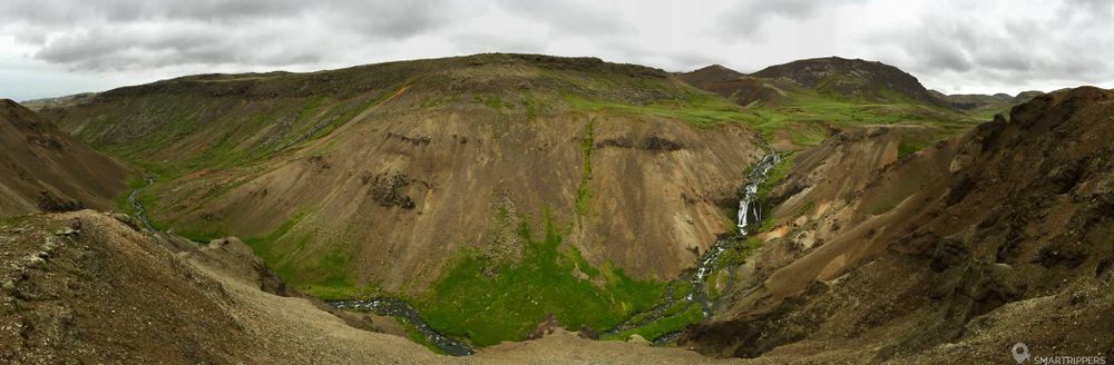
As soon as you arrive, you will be greeted by fumaroles who escape from the ground everywhere. You can feel the magma is not far away! To the north of Hveragerði, strange hills form a dam on the horizon. It is here that the highest concentration of geothermal phenomena can be found in the Reykjadalur Valley.
The river we are interested in is Reykjadalsa. It takes its source upstream at the top of the hills. On the way, it crosses a rift that feeds its stream with very hot water. This is how you can enjoy a unique swim in a hot water stream. Change of scenery guaranteed!

2Access to Reykjadalur Valley
From the city centre of Hveragerði, head north following the stadium direction. The road leaves the city and crosses a cultivated plain. At the stadium level, the road splits in two. Take the road that goes slightly to the left, signposted "Reykjadalur". 150 metres later, at the new fork, continue left again. After 2 km, the road ends with a small parking lot. Pull over. If the car park is full (which is often the case in summer), park on the side of the road.
A café, the Dalakaffi, is located right next to the car park and offers homemade pastries as well as a few drinks, the opportunity to make a gourmet stop after the hike.
3Hiking to the hot water river
Start of the ascent and discovery of the first solfatares
At the end of the car park, a bridge allows you to cross a river. On the other side, a wide path rises gently towards the summits, passing close to several smoke marshes and coloured solfatares (about 300 meters after the river).
The area is dangerous because the ground is unstable, do not approach solfatares and smoking holes.
The path continues its ascent and after a few bends, it narrows to become a path.
Be careful because the soil is very clayey and can be slippery in rainy weather.

The ascent continues, through a green hilly landscape. After about 20 minutes (approximately 1 km), the hills show a valley on the right. Below it, a river winds its way through a gradient of surprising colours. The green leaves little by little to brown and orange.
The grassy plain and its marshes bubbling with water
The climb now becomes softer. The path widens and takes us to a vast grassy plain. After a few hundred meters, we finally reach Reykjadalsa, which is not very hot at this place anymore. After a ford made up of a plate of sheet metal, the path narrows and now runs along the side of a hill dotted with volcanic rocks. In the distance, smoke seems to escape from the earth forming a large cloud of steam.

Approximately 400 metres after crossing the river, you will quickly see a dozen large, bubbling marshes on the right-hand side, whose presence is betrayed by the steam escaping from it. The water in the potholes is sometimes surprisingly blue! Some are calm while others are boiling. In some places, the earth spits out powerful whistle fumes!

Be extremely careful and stay away from holes. The ground can be unstable and collapse you your weight and you will be seriously burned....
A little further on, there are other marshes next to the path. This time they are much closer. The steam that escapes plunges part of the trail into a very humid and warm fog, filled with a sweet smell of sulphide.


Swimming in the hot water river
Once past the last marshes, there are only 300 meters to go before reaching the river again and its part suitable for swimming. It is impossible to miss the river on the right, from which regular fumaroles escape, indicating a high water temperature. A small wooden bridge overlooks the river and on the other side everything has been arranged to facilitate swimming.
A large pontoon pontoon runs along the river, so that you don't have to walk in the mud. At regular intervals, small stone dams have been shaped to create small ponds in the river. Thus segmented into a compartment, each one will find its own space for a well-deserved swim!

Some wooden screens allow clothes to be put down and changed away from the wind. Practical when it's cold! But no structure is covered, so in case of rain, remember to protect your business.
The river is fed by a very hot spring located a few hundred metres upstream of the bathing area. The higher you rise, the higher the water temperature will rise. The water is around 38°C / 40°C at the level of the basins. At the end of the pontoon, the trail continues along the river for a few tens of meters. This part of the river is very interesting for swimming because there is usually no one there. But you have to know that the water here is really very hot. We have had the burning experience of trying to settle there. It was simply impossible for us to sit down, because the water was so hot. Our legs were scarlet! We were finally forced to go back down to find a place a little lower.
Once in your pool, relax and enjoy! How nice it is!

Note however that it is a river, with its share of drawbacks. Expect to encounter a little mud and some algae, even if this is not embarrassing.
After swimming, you can decide to turn back, or continue the walk with an interesting 3.5 km loop that will allow you to discover other geothermal phenomena.
The Ölkelduhnúkur loop (optional)
After having passed the bathing area, the trail continues and makes a long loop of 3.6 km passing by various geothermal phenomena very interesting and varied.
- If you are on the left side of the river, continue straight ahead. The trail continues along the side of the black hill and will gradually rise to pass a small pass. Here the phenomena seem to be getting denser and superb solfatares appear.
- If you have crossed the river, so on the right bank side, proceed to the end of the pontoons. The path will reappear to split in two. This is the junction of the loop. Choose to take on the meaning you like. If you choose to turn left to make a clockwise turn, you will soon have to cross the river again. At this very spot, you will notice that the water seems very hot. This is where the hot water comes out of the ground and feeds the river.
Unfortunately, we were not able to complete the whole loop because the weather forced us to turn back. In case of rain, some portions are really very slippery. We recommend that the loop should only be carried out in dry weather.
4Vigilance et recommendations
The geothermal zone over the entire course is very active. Sometimes the crust of the soil is very thin and accidents are numerous in this area.
Do not leave the trails and never approach hot springs or solfatares. Danger is omnipresent and often invisible.
The unusual and very pleasant swimming in the warm river.
The many geothermal phenomena along the trail.
Practical developments along the river.
A lot of people in summer, don't expect to be alone.
We are Sandrine and Flo, French thirty-somethings. In 2019 we quit everything to live our dream, become nomads and travel around the world. We left with our baby, Lena, who was only 5 months old at the time. After a first trip around the Pacific Ocean by plane and a long 3 months stay in Hawaii, we left to discover Iceland for 3 months on board our 4WD pickup truck and truck camper. Then we continued our adventure in North America.

Today, if we can continue this adventure, it is above all thanks to our blog, Smartrippers! We created it one day in 2016, with the desire to share our good travel tips, without thinking that it would lead us there! We have developed it a lot over the years and have become experts on our 3 favorite destinations: Hawaii, Iceland and the American West. We now guide you to these destinations to help you plan the trip of your dreams!
Follow our adventures!