- Iceland
- South Iceland
- Hveradallir - Walk in the middle of the fumaroles

In the heart of Iceland, in the Kerlingarfjoll Massif, is one of the most fascinating places in Iceland. Imagine a landscape of orange hills dotted with snow. Add fumaroles, hot water rivers and solfatares of all kinds. Here you are in Hveradallir.
This place has upset me. I must say that this is the most intriguing place I have seen to date. You know how much I'm in love with Yellowstone Park, but since the discovery of Hveradallir, I must say that Yellowstone has been the number one place in my personal ranking.
Summary
1Access to the Hveradallir site
At the halfway point of the F35, the F347 forks towards the small Kerlingarfjoll mountains. The track is reserved for 4x4 because it is not in very good condition. The road gradually rises upwards and begins to overhang the immense volcanic plain.
On the way, you will come across the small waterfall Gýgjarfoss which rushes into small gorges. The trail continues its ascent by making a few bends, then arrives at the Kerlingarfjoll campsite after 7 km. Don't stop here unless you want to continue on foot along the beautiful hiking trail for the remaining 5 km.


The trail continues its ascent and sneaks into the middle of the hills. It is now high enough to begin to see the superb glaciers that surround the Kerlingarfjoll: Hofsjökull to the north-east, Langjökull to the west and the immense Vatnajökull to the south-east.
After about 5 km you will see a parking lot on the right. Park right here. The rest of the discovery will be on foot.
Walk in the middle of fumaroles and solfatares
At the end of the car park, an orientation table allows you to find your way. Admire this impressive landscape of snow-spotted orange hills. But to enjoy the site, you have to venture into the heart of the hills, and descend into their furrows. To do this, steps were dug into the hillside and embellished with wooden logs.

Be especially careful as the descent can be extremely slippery in wet weather.
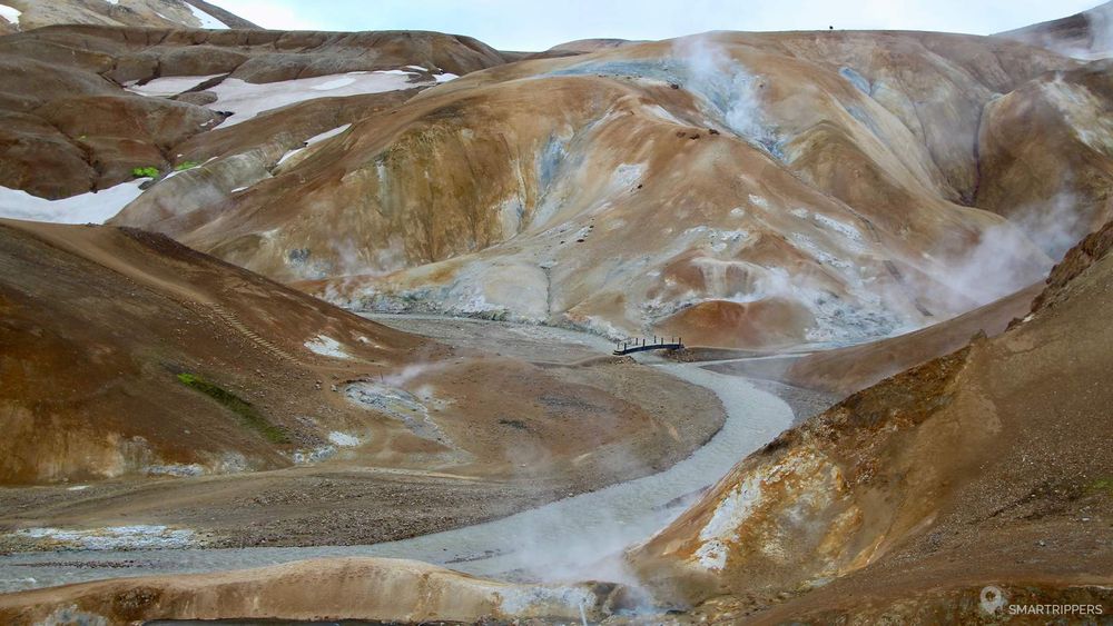
Now we are at the bottom of the valley. Take a look around you. The hills are smoking all over the place. Pink, green or ochre spots adorn the walls of some hills. A sulphur smell invades the atmosphere and plunges us into an apocalyptic atmosphere.

Exploration of the geothermal zone
From here, many trails start in a multitude of different directions. Surrender yourself to discover this mysterious and incredible site. Climb the hills, walk along the ridges, along hot streams, through thick clouds of smoke.

The trails are marked by stakes spaced about every 100 metres. Follow also the pontoons and logs that will show you the points of interest. Stroll at your own pace and explore this mysterious area.


Don't leave the trails because the area is extremely active and dangerous. One bad step and you could get burned very badly.
Look closely at the ground at the wooden pontoons in the middle of the valley. It's bubbling! Small ochre puddles crackle on the ground (do not set foot on it). In some places, whole sections of hill appear to be cooking. Colored solfatares spread over large areas from which steam escapes. Sometimes steam is so important that it completely envelops the trail. We find ourselves immersed in thick fog. Be careful as you move forward.


Sometimes the trail may pass through a solfatares zone while no wooden pontoon will secure the area. In this case, we recommend that you be extremely vigilant. Ideally, use a walking stick to make sure that the path you take is stable. If you come with children, stay together. If the path seems too uncertain to you, it is better to retrace your steps. The area is large enough to allow you to find other less dangerous trails.
The panorama on the smoking hills
The most beautiful view of the smoking hills is to the west. A path leads up a hill overlooking the entire site. This is the hiking trail that leads to the campsite. Cross the small wooden bridge over the steaming river and begin the ascent of the hill. It's quite steep and the ridge is narrow, but the imposing view at the top is worth the effort.


Everything! The exceptional setting of the orange hills still partially snow-covered
Smokeolles and solfatares in a mess...
Site layout with footbridges, pontoons and steps
Careful, it's slippery!
We are Sandrine and Flo, French thirty-somethings. In 2019 we quit everything to live our dream, become nomads and travel around the world. We left with our baby, Lena, who was only 5 months old at the time. After a first trip around the Pacific Ocean by plane and a long 3 months stay in Hawaii, we left to discover Iceland for 3 months on board our 4WD pickup truck and truck camper. Then we continued our adventure in North America.

Today, if we can continue this adventure, it is above all thanks to our blog, Smartrippers! We created it one day in 2016, with the desire to share our good travel tips, without thinking that it would lead us there! We have developed it a lot over the years and have become experts on our 3 favorite destinations: Hawaii, Iceland and the American West. We now guide you to these destinations to help you plan the trip of your dreams!
Follow our adventures!